Does anyone know the maximum grade on that short little hill between the Little Red Lighthouse and the 181 street overpass? Mainly the part from the viaduct to just past the sharp left turn.
Hill grade question
Mon, 05/03/2004 - 1:14pm
Mon, 05/03/2004 - 1:22pm
#1
about 4%?
Mon, 05/03/2004 - 3:58pm
#2
Not there. You must be thinking of the wrong hill. That thing is WAAAAAAAAAAAAYYY over 4% - It is the only place in all of NYC where I use my 24x34 gear.
Wed, 05/05/2004 - 8:56am
#3
you are correct
"I was just guessing the vicinity, like ""Broadway from Nagle Av to 181st St"" - hence the question mark notation. The area you describe sounds remote, one where finding a few dead bodies is not so uncommon. Perhaps some of those stiffs are attributable to the steep cardiac arrest inducing climb."
Thu, 05/06/2004 - 8:30am
#4
"Its not a remote desolate place at all. Its part of the westside greenway. The greenway goes pretty much flat all the way to the little red lighthouse. From there, there is an uphill, then a wooden bridge, then it goes under a small viaduct, and that's where the steep section starts. If you look at the picture below - the road to the left goes to the little red lighthouse (dead end), and the road to the right goes up the hill."
Mon, 05/03/2004 - 3:27pm
#5
4%???
Heck no! Maybe it's because it comes right after 15 miles of flats from Chambers St., but it seems more like 12-15% to me. It's short too, but that 180+/- turn makes it fun! I think it's about the same grade as Ash in Piermont.
Mon, 05/03/2004 - 3:39pm
#6
11%
I checked a ride I did on Dec 23, 03: it's a 55 foot gain in 500 feet (both appr. and according to Polar) = 11%
Wed, 05/05/2004 - 8:42am
#7
26% in Passaic Valley
In NJ, a couple miles west of the Hudson River, coming out of the Passaic River valley are a bunch of hills that are really step. Elm St (the “nightmare”) while maybe 1/4 - 1/3 mile long, is 26%. Cars are afraid to use it and several drivers stop and tell us cyclist there are more gentle hill south – and they just shake their heads as we thank them and pedal on. The steepest I know around here.
Wed, 05/05/2004 - 9:09am
#8
whereabouts?
"A couple miles west of the Hudson River and coming out of the Passaic River - would that be Newark or therebaouts?
I have an A ride listed this month that contains quite a few ""steeps"". I haven't done the grade calculations myself, but one can get the ugly (topography) details here... Lebanon, NJ"
Wed, 05/05/2004 - 9:56am
#9
26% Elm St. in ...
... North Bergen or Fairview, NJ, south of the GWB, north of The Lincoln Tunnel/Port Imperial.
Elm, and similars, run west of and descend from Bergen Blvd. Larger streets that run parallel to Elm are Ray and Jersey, but are not as steep.
Wed, 05/05/2004 - 10:06am
#10
I must add...
Elm and the others, while a challenge, are in a semi-urban/sub-urban sprawl. Shopping malls, blvds, strip malls. It's nice as a detour to/from GWB and south on River Road.
Your ride sounds, looks exceptionally hard. I know those profiles may make a 4% look like Everest, but 6600' in 52 miles!!!!! My rule of thumb; 1 mile of ascent in 100 miles is alot. This is more than double that!! Yeow!!! Maybe next year ;-)
Wed, 05/05/2004 - 10:54am
#11
Thanks for the info
"I ride a bit through Hudson County and thought I hit the motherload of all hills in the area when I introduced Undercliff/Edgewater Ave to Hank S., the Hill Grade page author.
With Undercliff at ""only"" 13%, that's hardly so. I'll be sure to funnel my way deeper-in (west) and seek out Elm St. Thanks again for the 411.
There's a popular Japanese saying which goes something like: ""It's wise to climb Fuji once, but only a fool does it twice."" Perhaps the same will be true of the May 22nd ride."
Mon, 05/03/2004 - 3:22pm
#12
that killer hairpin
Judging by the grades included on the 'Making The Grade' page, I'd say that short bit is over 10%.
I barely get up in my easiest gear. Though it's short, I know of nothing steeper in Manhattan.
Tue, 05/04/2004 - 6:51am
#13
Steepest street in the world?
Baldwin Street, Dunedin, New Zealand with a gradient of 1 in 2.66, or 38%.
What's the gearing for that?
Tue, 05/04/2004 - 6:53am
#14
PS.....steepest street in the world
how one cyclist handled it.....
http://www.bikereader.com/BikeReader/contributors/Ainsley/hills.html
Tue, 05/04/2004 - 11:16am
#16
holy cat crap, bat man! how THAT'S steep!!!
"i guess one picture tells it all..."
Wed, 05/05/2004 - 9:49am
#17
Steepest grade in NJ
Kyle Chu, one of the organizers of the Hillier Than Thou race sponsored by the Central Jersey Bicycle Club, told me Saturday that there is a stretch of Fiddlers Elbow Road in Harmony, N.J. (which is in the race every year), that reaches 38 percent grade. It's hard to keep your balance WALKING the bike up that stretch.
Thu, 09/08/2016 - 12:49pm
#18

RE: 26% Elm St. in ...
Sorry to resurect an old thread, but I'm wondering if anyone was able to find Elm St? I've been trying to locate it from the descriptions above, but have had no luck. I'm riding in the Hillier Than Thou and Pittsburg Dirty Dozen rides this year, and I need to find some 20%+ hills so I can figure how to climb such a thing! :)
I can't seem to locate the lone hill over 20% listed in the Regional Hill Grades page, either (Joes Hill Rd in Putnam County, below). I'm actually riding to Cold Spring this weekend, so I'd love to find that one.
Putnam County | |||||
| E Mtn Rd, start of climb east side to crest | 1.58 | 7.18' | 8.6% | ||
| Cold Spring/McKeel Corners (Rt 301): | |||||
| Main St, Cld Spng at depot to Rt 9 | 2.79 | 440' | 3.0% | ||
| Main St, Cld Spng at depot to crest Rt 301 | 6.61 | 1158' | 3.3% | ||
| Indian Spring Rd – west of 9D to Dennytown Rd | 4.39 | 760' | 3.3% | ||
| Indian Spring Rd – Loch Lyall to above Reeves Pd | 0.70 | 310' | 8.4% | ||
| Canopus Hill Rd – whole length | 1.36 | 521' | 7.3% | ||
| Canopus Hill Rd – steep section to Albany Post Rd | 0.29 | 180' | 11.8% | ||
| Joes Hill Rd – steep section | 0.04 | 50' | 23.7% | ||
| Joes Hill Rd – section below steep section | 0.10 | 50' | 9.5% | ||
Thu, 09/08/2016 - 1:33pm
#19
.png "2011 B-SIG Grad")


.
You know, I've been thinking for 4-5 years to make that trip to the Pittsburgh DD, but I keep having circumstances where I miss it (particularly because it's difficult and expensive to travel alone for it). I keep it in the back of my mind because I know I want to do it someday... it's terrible to hear about what happened to Danny now, but I'm sure it'll continue...
Because I'd been scouting for this stuff, Elm St is actually Elm Ave. in Ridgefield, NJ. There are MANY streets in this area going up/down the cliff plateau that are incredibly steep, along the lines of Speer etc. The main roads can get rather busy so you might want to just plot the side streets for hill repeats. Here it is:
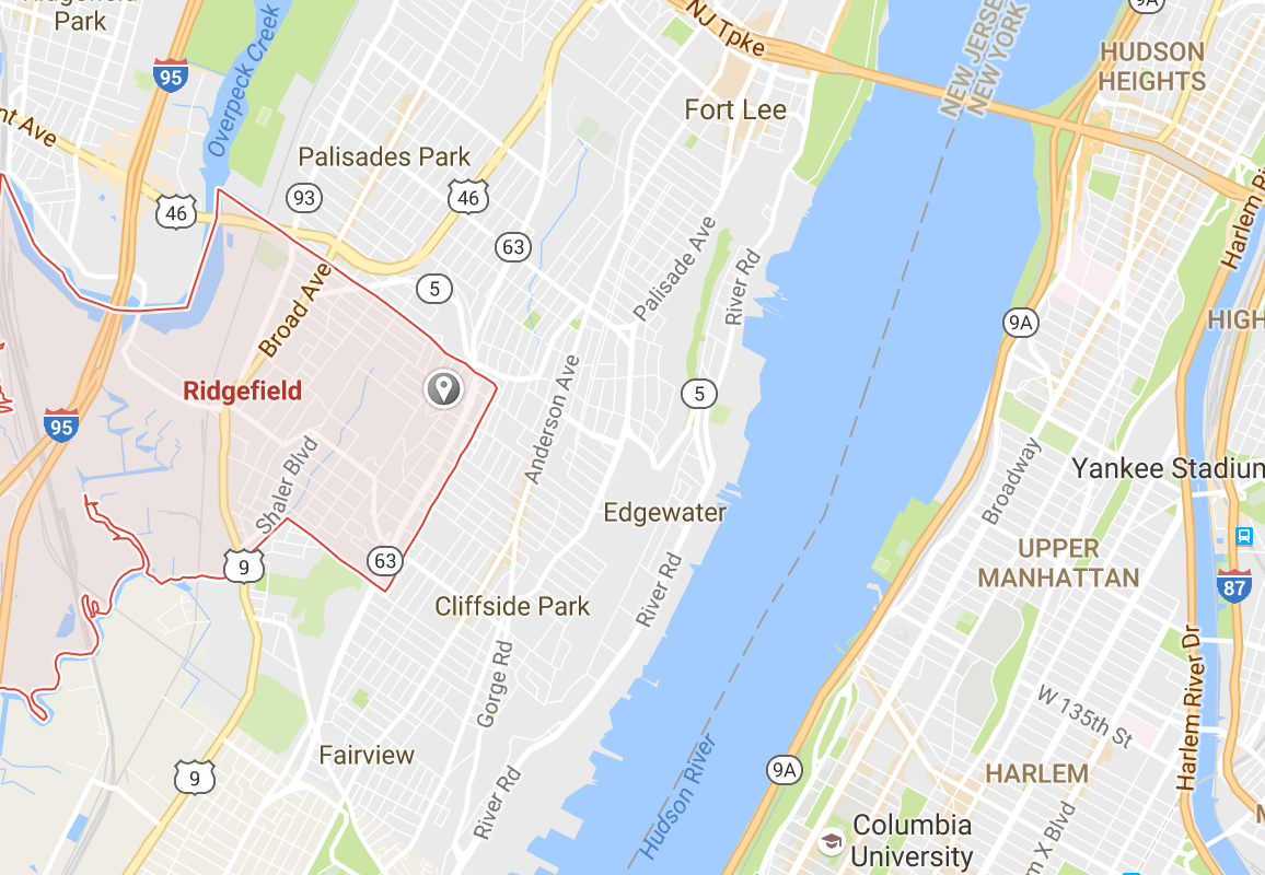
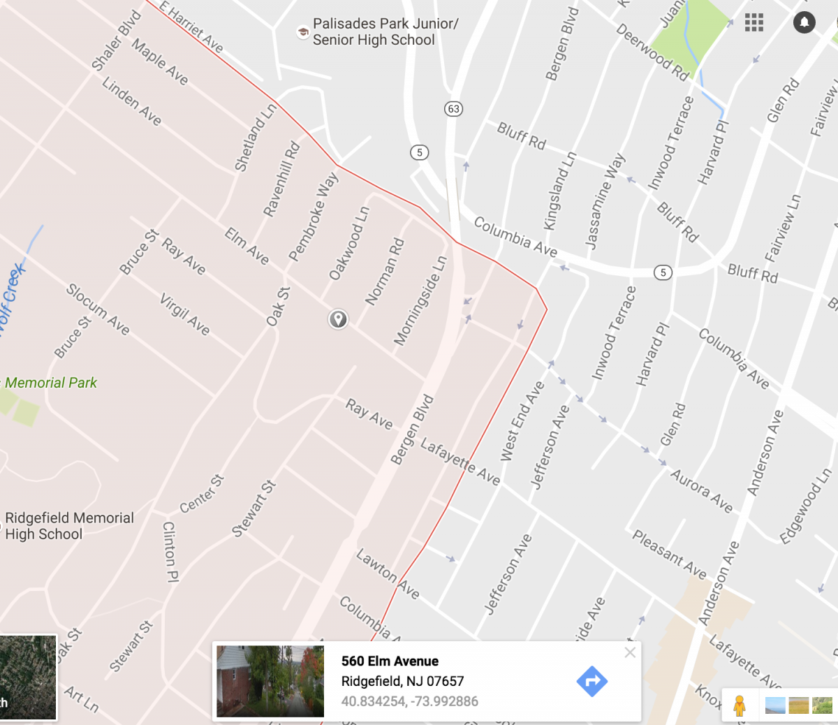
Thu, 09/08/2016 - 8:09pm
#20
Thank you!
My brother-in-law came from Missouri to participate in the DD in 2014, and has convinced me to go ride it with him this year. I'm sorry for Danny, and I hope he makes a full recovery. From what little I've heard/read about him, if anyone could make the best of it, he will. Sound like his friends will ensure the ride happens this year, and if it does, I'll be there.
Thank you, for the Elm Ave info, BVan! It's even closer to Manhattan than I thought. It looks deceivingly flat on Google Maps terrain, but I see that RWGPS shows it is up to at least 16%. I'll head over there to explore the area in the next week or two.
Thu, 09/08/2016 - 4:43pm
#21
why not just ride the segment
why not just ride the segment and look at the results on Strava?
Thu, 09/08/2016 - 6:42pm
#22

And Joes Hill Road is in
And Joes Hill Road is in Brewster
Thu, 09/08/2016 - 6:51pm
#23

There are no 20% sustained
There are no 20% sustained grades in our region. Shorter, steep sections are difficult to nail down exact grade due to errors in small values. Even Mt Washington's final 20%+ grade is hard to quantify as it is short, and you can take a less direct line being an ess shaped curve.
If you desire to get a feel for what real steep is, try taking Vista Maria all the way to the top, or Devil's Kitchen. Tinker will do as well. In each of these you will realize the difference between steep and very steep as the climb's grade intensifies. The increased grade will add insult will to the injury of the sustained ascent. You will find yourself out of the saddle and pulling back on the handlebars searching for that sweet spot where traction and power intersect. Anything less will not work.
You are praying at the altar of a vengeful god.
Thu, 09/08/2016 - 8:56pm
#24
Vista Maria!
Thanks, Mr. Schiffman. Minnewaska looks like a gorgeous place. You just inspired the rough draft of a new route (for me, anyway) from the GWB to Minnewaska, to climb Vista Maria up to Sam's Point, on the way to either Poughkeepsie or Otisville. I'll have to see if anyone else has done a similar route.
https://goo.gl/maps/4h97Z4VWhPQ2
Thu, 09/08/2016 - 9:07pm
#25
You can go only as far as the
You can go only as far as the Sam's Point visitor center, where there is water and restrooms, bikes are not allowed any further.
But you didn't need that extra mileage anyway.
And save youself a few more unnecessary mile and stay on 44/55 to 299, by then you will have had a very full day.
Mon, 09/12/2016 - 10:08am
#26
To address the OP (Does
To address the OP (Does anyone know the maximum grade on that short little hill between the Little Red Lighthouse and the 181 street overpass? Mainly the part from the viaduct to just past the sharp left turn), since I'm seeing some incorrect information here -- the max grade of that section is 22.5% approaching the hairpin turn. The segment is called "Just the hardest part" on Strava if anyone on there wants to take a look.
Mon, 09/12/2016 - 2:58pm
#27
That sounds right. I once
That sounds right. I once manually calculated around 20% for the section at the very top using the data from my garmin and mapping software
Mon, 09/12/2016 - 7:49pm
#28
Again, very short segments
Again, very short segments are subject to too many variables to get a true breakdown of grade. And if you were to average the whole shebang the result would be unrepresentative of the experience.
For the segment that is the real steepness from the underpass to the let up before the 182nd St overpass, are all measurements spot on? More than likely at least on value is off, wildly throwing the results into the realm of inaccuracy.
Real steep is like jazz; one needs not to define it because you know it when it comes your way.
Mon, 09/12/2016 - 9:06pm
#29
No disagreement from me. Just
No disagreement from me. Just answering the OP, since I noticed a correct response hadn't been given.
Tue, 09/13/2016 - 10:01pm
#30
Here's a fun topical video
Here's a fun topical video for anyone who hasn't seen it before -- doesn't take place in our neighborhood alas.
https://vimeo.com/32720991 (jump to 0:50 if you are feeling impatient)
Wed, 09/14/2016 - 6:33am
#31
reminds me of the climb to
reminds me of the climb to the girona cathedral after a long ride.

