Clausland, Bradley and Tweed, Jay’s Own Backyard Playground
Clausland, Bradley and Tweed, Jay’s Own Backyard Playground
By Jay Jacobson (member since the 1990's)
 No other biking route or roads this close to Manhattan can compare, in my opinion, to this complex of roads, terrain and scenic magnificence. Majestic views of the lower Hudson estuary with fjord- like features, four seasons of splendid foliage and challenging cycling terrain all come with it! Corniches, climbs and descents such as these are what cyclists travel to Europe, Colorado and California for.
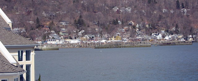
In the eight years we have lived in Piermont I have enjoyed a visual festival from our windows of the Clausland Mountain Ridge, Tappan Zee Bridge, Piermont’s village and its harbor. At night we marvel at the black vista punctuated by the twinkling lights of the homes along, (and the vehicles travelling on) these three south/north roads: Piermont Ave./River Road, 9W & Tweed Blvd.
Descents and Ascents Cycling on flat surfaces is tantamount to playing baseball with only first base, no second or third base and no home plate! Climbs are challenging and downhills are exHILarating but can be dangerous. Some of the more dramatic climbs are South Highland Blvd (between Old Mountain and Tweed) a quarter of a mile with a 147 foot rise and an average grade of 8.8%; Ash a third of a mile with a rise of 205 feet and average grade of 12.1%. Clausland Mountain Rd is .31 mile, 180 feet and 11%!
The southern end of Tweed(CR5) is very steep as it intersects with 9W. If a cyclist loses control of his bike on this downhill he will “fly” into 9W’s traffic which can be moving at 50 mph or more. That is why I frequently WALK my bike downhill here. At some times of the year there is also gravel on the precipitous downhill. The short uphill gradient here is very difficult.
The first 200 feet or so of Clausland Mountain Road (CR28)going up is quite arduous, but beyond that it becomes more gradual. Clausland’s altitude is 700-800 feet or so. It was named after Jan Claus who acted as an agent for the sale of land to the Dutch settlers. His Indian name was Tackamack, which is the name for a town park on the cyclist’s left side as he or she ascends.
The park has open space and adjoins county and state parks. The local teenagers have nocturnal trysts in the park. Some of us refer to it as “Condom Park”!
 Access and routes There are several recommended ways to get into this wonderful group of state, county and town parks and hills. Coming north on Western Highway (using the Orangetown rail trail or from Oak Tree Road through Tappan, N.Y)., cross the bridge just before Orangeburg Road and turn right at Bataan Rd (named after a bloody World War II battle in the Philippines called the Bataan Death March—there was a giant military training base here at that time) Another right on to Mountainview and cross busy Route 303. Left at Greenbush Rd. One option at this point would be a right on Clausland Mountain Rd (CR28)-steep! Or continue on Greenbush. It runs into 303, but stay on the narrow shoulder for about 75-100 feet and then Greenbush veers off to the right and continue to CR 38 (there is a brick ranch house on the near right corner but no sign for Bradley Hill) Right on Bradley and start climbing. Bradley was named after the Bradley family-Stephens Sr. & Jr. (electricity and electric wire magnates)
Bradley eventually runs into Nyack College which overlooks Nyack. An alternative just before that is to take Tweed Blvd (CR5) by turning right. While gaining altitude the cyclist will notice they are riding along a corniche on the left. There are excellent views of the Rockland County skyline, especially when the foliage is not full. The residential acreage on both sides of the road changes to dedicated but undeveloped parkland
Just before reaching Nyack College at the top of the hill is the 15 acre Sean Hunter Ryan Memorial Park. Sean, who was a nature lover and Rockland County resident, became a park ranger. He tragically fell to his death during a very dangerous rescue attempt at Mt Rainier National Park in Washington State. Wild turkeys, scarlet tanagers, red-eyed vireo and blue jays have been sighted in this park.
Cyclists going north through Piermont can continue straight on Piermont Ave which continues as River Road in Grand View. The road runs under the Tappan Zee Bridge which is being replaced by a multibillion dollar new span, which will have a bike lane. After passing the bridge, make the first left on a thru street (Cornelison) and then turn right on Nyack’s South Broadway. In Nyack’s commercial district turn left on Depew and go uphill to 9W (turn left there)
Stay left at the fork for Highland Ave (not 9W) Make a right turn to pass along Nyack College’s athletic fields. At the end of Highland, it runs into CR38 Bradley Hill Road.
Tweed can be accessed by bearing left off 9W just North of the school in Piermont’s upper village. As I indicated before, this is a steep road off a very busy thoroughfare.
 Tweed Blvd runs across the ridge or top of the hill(s) from Bradley to 9W. From Bradley it gradually rises until the intersection with Clausland Mountain Rd (CR 28) This intersection has 4 stop signs and is called “The Knot”. Just before and after the knot, the park ends on the river side and there are exquisite homes having river panoramas to die for. In the 1970’s homes up there were going for $50-70,000 but I was told by Joan and her mother it would be dangerous—they envisioned our daughters tumbling down the hill ala Jack and Jill. Now most are priced above a million and some much more!
I was leading a group of strong bicyclists up Tweed. Somewhere around the knot I asked them “Those were some outstanding views on the left?” Their responses were only blank looks. They were obviously too busy pedaling up the incline to even turn their heads to appreciate the scenic feast! If you are pumping like that, at least when you see a break in the shrubbery, just stop, catch your breath and look around!
There is a midsummer wild raspberry crop growing on the river side of Tweed north of the knot. Cyclists who have conquered these hills can reward themselves with a fistful!
Tweed got its name from the infamous “Boss” Tweed of Tammany Hall fame, who was a railroad tycoon and had a home up there. Most of Tweed Blvd transverses the “hamlet” of Upper Grand View which is in the town of Orangetown. It ends in the upper part of Piermont. About a mile or so past the Knot on the right is Nike Town Park featuring open space and scenic views. During the Cold War the site served as a radar tracking station.
The road then narrows and descends a bit just before turning to the left and dropping sharply into 9W. At 9W cyclists can make a tight right turn onto the narrow shoulder of 9W South. If they make the first right after that, they go into Sparkill and eventually Piermont.
A second alternative is to CAREFULLY cross 9W, then take the downhill towards Piermont. Because I eschew riding down 12% graded Ash St, I turn left at the restored train station and go a few blocks on Hudson Terrace until Bay St. Bay St gradually goes down to Piermont Ave about a half mile north of the commercial district of Piermont.
I do not recommend turning left on 9W towards Nyack. The shoulders are narrow especially relative to the heavy and fast moving traffic on the 2 lane road. There was a bicyclist fatality there recently which resulted in the installation of one or two “Share the Road” Signs.
Trees and Animals: Hardwoods in the area include red and white oak, maple, hickory, beech, dogwood, and thick groups of hemlock and mountain laurel. Animals which have been spotted include great horned owl, woodpeckers, robins, thrush, red tailed hawks, white tailed deer, raccoons, chipmunks, opossum, woodchucks, porcupines, skunks and black and garter snakes.
Cross training The area is criss- crossed with hiking trails including the 300 mile Long Path which runs from Fort Lee, N.J. to upstate New York. It is marked by blazes painted green in upright rectangles. Off road mountain biking is generally prohibited in these parks.
Safety There is light auto traffic on these roads. A high percentage of bike accidents happen on downhills. I learned this the hard way. Since” I like my bones”, I keep my bike under control by braking equally on both sides, leaning back and I personally would unclip or take my feet out of the pedal straps. Care should be taken by riders leaving the area onto 9W or other busy roads.
 Environment The roads are fairly well maintained and there are relatively few potholes Residents could do a better job of disposing of tires, old appliances and general household rubbish. Local government agencies should make the disposal of these items easier. Perhaps organizations such as Adopt a Highway, Boy Scouts, etc. should actively organize cleanups .In any event the lush summer foliage should hide most of the debris,
Club Rides NCC ride leader Richard Rosenthal leads fast and difficult level B rides “ClimBathons” in the area. I have also led some of my “LoHud Series/West Bank Vista” rides there. Cue sheets for “The Knot” and other rides are on the NYCC web site under rides/ride library.
Maps The Rockland County Environment Dept has an on line relief map on its web site. Go to GIS Maps. The Trails Conference(available at outdoor stores, etc.) and US Dept of the Interior’s Geological Survey also have excellent maps.
Nyack College’s main campus is at the high northeast end of Bradley goes into South Nyack. The college which has over 3,000 students claims to be the most “ethnically diverse Christian College” in the U.S. Most of its building have splendid riv vus. BTW it is moving its Manhattan campus to Battery Park this year.
Eat to Ride/Ride to Eat
- Patisserie Didier Dumas 163 Main St Nyack. Superb baguette sandwiches, crepes, quiches and pastries, outdoor seating
- Runcible Spoon 37 N Broadway Nyack. The runcible spoon is a spoon shaped fork from Lear’s “The Owl and the Pussycat” outdoor seating
- Bunbury’s Coffee Shop 460 Piermont Ave Piermont
- Canzano’s Market 254 Piermont Ave., Piermont (along canal behind the old mill building) yummy sandwiches but no seating or rest room.
- Palisades Market & Filling Station on 9W just north of Oak Tree Rd and NYCC Adopt a Highway Sign- park like setting. On rides I lead I am frequently unable to get cyclists out of the comfy patio chairs and back on their bikes! It is owned by our friends, Stravos and Agata.
Did You Know?
There are over 3,000 counties in the US. Rockland has the highest percent of Jews of any of them
Bike Shops
The Piermont Bicycle Connection has an extensive inventory of bikes, parts, clothing and accessories as well as outstanding service. Within the Piermont shop is a branch of Nyack’s Gypsy Donuts (far better than Dunkin or Krispy I think), a coffee bar and a few outdoor picnic tables. Manhattan’s Toga Bike Shop has a branch on 9W in Upper Nyack. Toga will pick up stranded cyclists having mechanical problems within a 10-15 mile radius (845-358-3455).
The sources for some of this information are the web sites of NYCC, Rockland County & Orangetown.
Contact the writer at: [email protected]

